Site Activities Update, to February 20th, 2023
The project field work in Phase One drilling is largely complete. One drill rig continues to operate and the emphasis is now on incorporating the data generated by the c75 holes in c47,000m of completed drilling into the upcoming mineral resource estimate and preliminary economic assessment.
Since the start of 2023 we completed drill holes S020 and S021 at South Zone, and N044 and N045 at the southern reach of the North Zone. Last week we collared N046 which will drill a horizontal hole from a position immediately adjacent to the collars of N044 and N045. We hope to explain the targeting and disposition of the single drill rig horizontal/shallow program below.
We haven’t dispatched any samples to the lab in Hermosillo – we expect that N045 will be shipped in its entirety when site processing completes.
We have received numerous queries regarding the rationale for, and the disposition of, the horizontal / shallow angle drill hole program we are conducting at the south end of the North Zone. The program grew out of recognition that mineralization extends westward of the historical grade shell in the southern reach of North Zone, and appears to be shallow with respect to the west slope of the North Zone / Sto. Thomas ridge. However, the target zone isn’t readily accessible using our conventional approach (cliffs and steeply dissected topography), so we arranged with Major Drilling for the deployment of a modified underground rig that would allow us to transect the targets using flat & shallow angle drill holes.
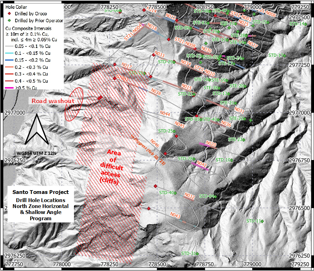
Map illustrating the locations of the horizontal/shallow angle drill program (holes N044 to N046). Click on the image to see an interactive 3D video of the target mineralization.
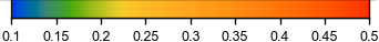
The video file will play on clicking on the Map Image above, or can be controlled using the slider. Elements of the video include the pink solid or sectional trace representing the historical grade shell, the drab olive solid representing a area or chargeability greater than 17.9mV/V and the late visible green outline representing a zone of low resistivity (< 2.2 Ohm.m). Drill traces appear as thick grey lines, some showing Composite Grade Intervals where Composites of ≥ 10m of ≥ 0.1% Cu, including up to 4m of ≥ 0.05% Cu, are displayed against the colour ramp below:
% Cu
We trust this helps you visualize this part of the program at Santo Tomás.
___________________________________
NEWS RELEASE February 2, 2023 - Oroco Drills 187.9 m of 0.58% CUE equivalent at Santo Tomas
VANCOUVER, British Columbia – (February 2, 2023) Oroco Resource Corp. (TSX-V: OCO, OTC: ORRCF) (“Oroco” or “the Company”) announces assay results from drill holes S004 through S018 (8,547 m of drilling) of its South Zone drilling program at its Santo Tomas property (the “Property”) located in northwestern Mexico (see Table 1, Figure 3 and the South Zone cross-sections, attached). To view an interactive 3D model that includes the South Zone results announced today, please use the following link: https://vrify.com or visit Oroco's website: www.orocoresourcecorp.com.
DRILL RESULT HIGHLIGHTS:
- Drill hole S004 (Plate SZ-47) returned 127.0 m of 0.41% CuEq
- Drill hole S015 (Plate SZ-44), returned 179.2 m of 0.45% CuEq
- Drill hole S016 (Plate SZ-43), returned 349.1 m of 0.40% CuEq
- Drill hole S018 (Plate SZ-44-A), returned 187.9 m of 0.58% CuEq and 234.3 m of 0.40% CuEq
- South Zone strike length spans two kilometers.
Richard Lock, Oroco’s CEO, commented: “We are extremely encouraged by our current drilling results. They are beginning to confirm the mineralization which was indicated by the historical drilling in the South Zone, therefore adding to the impressive results from our North Zone drilling program. We anticipate that these results will come together very positively in support of our Preliminary Economic Assessment, which is expected in the second quarter of 2023.”
SOUTH ZONE PROGRAM
The Company has now completed a 21-hole South Zone drill program (12,154 m) designed to confirm and test the South Zone mineralized structures, with the assay results up to drill hole N018 now being reported, and those of holes S019 through S021 currently pending.
All drill holes tested the deposit approximately perpendicular to its structural attitude. Core intervals are within approximately 10% of true thickness. Assay results and cross-sections of all South Zone, North Zone and Brasiles Zone drill holes released to date are available at the Company’s website.
Historical drilling, surface geological mapping, and the Dias Geo 3D Induced Polarization survey have defined near-surface mineralization projected to 400 m below the surface along 2,000 m of strike length in the South Zone.
The South Zone is only partly tested by the current drill program. However, the historical drilling and the 2022-2023 drill program conclusively define a NNW to NNE trending zone of faulting, Laramide-age intrusion, hydrothermal breccias and mineralization along the entire two kilometer corridor south of drill hole N034 of the North Zone.
- The northern segment of the South Zone, between drill holes N034 and S012, representing a 500 m long undrilled corridor, will be tested in a future drilling program.
- The middle segment of the South Zone extends from drill hole S012 southward to hole S007 (Plates SZ-49 to SZ-63). Current drilling demonstrates a zone of moderate-grade, shallow-seated mineralization to a depth of 200 to 400 m below surface along a strike length of approximately 700 m. Continuity in this area must be confirmed by additional drilling.
- The southern segment of the South Zone extends southward from drill hole S007 along a strike length of approximately 800 m. Drill holes S004 to S017 (Plates SZ-47 to SZ-38), including the previously released S003 (277.4 m of 0.39% CuEq) and S004 (127.0 m of 0.41% CuEq), demonstrate continuity of good grade mineralization within a southwest plunging zone 300 m in width, extending from surface to 200-400 m in depth. As these drill holes test an area of the South Zone that begins within and extends beyond the historical resource, they have the potential to add significant tonnage to the mineral resource estimate being prepared in support of the planned Preliminary Economic Assessment.
DRILLING RESULTS – MIDDLE SEGMENT OF THE SOUTH ZONE
- Drill hole S005 (Plate SZ-51), collared on the west side of the higher chargeability anomaly, returned 54.2 m of 0.28% CuEq.
- Drill hole S006 (Plate SZ-56), returned one of the best near surface drill holes in the South Zone to date with 146.6 m of 0.43 CuEq commencing within 20 m of surface.
- Drill hole S007 (Plate SZ-49), collared on the eastern fringe of a chargeability anomaly returned only marginal mineralization.
- Drill holes S008 and S010 (Plate SZ-52), returned only marginal intervals of mineralization.
- Drill hole S009 (Plate SZ-58), returned only two short intervals of good grade mineralization: 23.2 m of 0.39% CuEq and 24.3 m of 0.32% CuEq, but appears to correlate well with S006 to the south and S012 to the north.
- Drill hole S011 and S013 (Plate SZ-54), intersected only marginal intervals of mineralization.
- Drill hole S012 (Plate SZ-63), returned three mineralized intervals, with the main interval being 82.0 m of 0.42% CuEq. This intersection remains open to the north into the gap of drilling between the North and South Zones.
DRILLING RESULTS – SOUTHERN SEGMENT OF THE SOUTH ZONE
- Drill hole S004 (Plate SZ-47), returned three mineralized intervals, with a main interval of 127.0 m of 0.41% CuEq.
- Drill hole S014 (Plate SZ-41), collared approximately 120 m south of S003, cut and confirmed STE-54 while extending mineralization a further 200 m to depth (with the best grades found at depth). S014 returned three mineralized intervals: 44.0 m of 0.32% CuEq, 146 m of 0.28% CuEq, and 66.0 m of 0.34% CuEq.
- Drill hole S015 (Plate SZ-44), returned three mineralized intervals, with the main interval being 179.2 m of 0.45% CuEq.
- Drill hole S016 (Plate SZ-43), returned three mineralized intervals, with a significant main interval of 349.1 m of 0.40% CuEq.
- Drill hole S017 (Plate SZ-38), returned one main mineralized interval of 142.0 m of 0.27% CuEq.
- Drill hole S018 (Plate SZ-44-A), returned three mineralized intervals, of which the most significant are 187.9 m of 0.58% CuEq and 234.3 m of 0.40% CuEq.
The southern segment of the South Zone has a contrasting geology to the North Zone. The North Zone is a body of sheeted, west-dipping Laramide-age intrusive dikes and mineralization. Drilling of the southern segment has intersected similar west-dipping intrusions and mineralization but also cut a slightly younger overprinting of mineralized hydrothermal breccia bodies and a wide body of stockwork vein and fracture mineralization. Grades are comparable to North Zone and locally extend over wider intervals than seen in the North Zone to date.
Table 1: Significant Assay Intervals in the 2021-2023 Program, Drill Holes S004 to S018:
Drill
Hole
No. |
Dip |
From
(m) |
To
(m) |
Length
(m) |
Cu
% |
Mo
% |
Au
g/t |
Ag
g/t* |
CuEq
% |
| S004 |
-55 |
64.0 |
84.3 |
20.3 |
0.26 |
0.003 |
0.041 |
2.01 |
0.30 |
| " |
-55 |
107.0 |
130.0 |
23.0 |
0.30 |
0.002 |
0.036 |
3.39 |
0.33 |
| " |
-55 |
167.0 |
294.0 |
127.0 |
0.37 |
0.002 |
0.049 |
2.09 |
0.41 |
| S005 |
-55 |
201.6 |
255.8 |
54.2 |
0.25 |
0.006 |
0.015 |
1.48 |
0.28 |
| S006 |
-55 |
35.5 |
182.1 |
146.6 |
0.37 |
0.002 |
0.073 |
2.89 |
0.43 |
| S007 |
-55 |
135.0 |
200.0 |
65.0 |
0.14 |
0.003 |
0.010 |
1.88 |
0.16 |
| S008 |
-55 |
186.0 |
230.0 |
44.0 |
0.22 |
0.013 |
0.018 |
2.16 |
0.28 |
| S009 |
-55 |
47.7 |
119.0 |
71.3 |
0.14 |
0.001 |
0.026 |
1.15 |
0.17 |
| " |
-55 |
148.9 |
172.1 |
23.2 |
0.32 |
0.002 |
0.079 |
1.72 |
0.39 |
| " |
-55 |
180.0 |
204.3 |
24.3 |
0.28 |
0.001 |
0.041 |
1.82 |
0.32 |
| S012 |
-55 |
157.0 |
239.0 |
82.0 |
0.37 |
0.004 |
0.032 |
3.25 |
0.41 |
| " |
-55 |
241.0 |
264.1 |
23.1 |
0.22 |
0.004 |
0.008 |
1.75 |
0.24 |
| " |
-55 |
272.1 |
314.0 |
41.9 |
0.19 |
0.002 |
0.006 |
1.75 |
0.20 |
| S013 |
-55 |
37.0 |
103.0 |
66.0 |
0.23 |
0.002 |
0.041 |
2.97 |
0.27 |
| S014 |
-55 |
116.0 |
160.0 |
44.0 |
0.29 |
0.006 |
0.014 |
2.71 |
0.32 |
| " |
-55 |
166.0 |
312.0 |
146.0 |
0.24 |
0.008 |
0.014 |
1.89 |
0.28 |
| " |
-55 |
318.0 |
384.0 |
66.0 |
0.26 |
0.018 |
0.009 |
1.63 |
0.34 |
| S015 |
-55 |
10.0 |
57.0 |
47.0 |
0.35 |
0.008 |
0.018 |
1.84 |
0.40 |
| " |
-55 |
78.4 |
257.6 |
179.2 |
0.36 |
0.020 |
0.022 |
1.92 |
0.45 |
| " |
-55 |
259.4 |
275.0 |
15.6 |
0.23 |
0.11 |
0.008 |
1.69 |
0.28 |
| S016 |
-80 |
88.0 |
437.1 |
349.1 |
0.36 |
0.006 |
0.027 |
2.34 |
0.40 |
| S017 |
-55 |
187.0 |
329.0 |
142.0 |
0.21 |
0.12 |
0.15 |
1.38 |
0.27 |
| S018 |
-35 |
6.7 |
42.0 |
35.3 |
0.27 |
0.009 |
0.010 |
1.89 |
0.31 |
| |
-35 |
64.1 |
252.0 |
187.9 |
0.51 |
0.012 |
0.038 |
2.49 |
0.58 |
| |
-35 |
260.0 |
494.3 |
234.3 |
0.34 |
0.012 |
0.017 |
1.66 |
0.40 |
Cu Equivalent (CuEq) % = Cu % + (Mo %*3.75) + (Au ppm*0.752). The commodity prices (3 yr Average) used are in $US: Cu $3.20 /lb, Mo $12.00 /lb, and Au $1,650.00 /troy oz. Ag values are not used in the CuEq calculations.
NORTH ZONE PROGRAM
The Company is continuing its horizontal drilling from the base of the Santo Tomas ridge testing the southern 400 m of the North Zone, south of hole N038, to depths of 300 to 500 m below surface. This previously untested area of the North Zone also has the potential to add significant tonnage to the resource estimate being prepared in support of the planned Preliminary Economic Assessment.
TECHNICAL INFORMATION AND QUALITY CONTROL / QUALITY ASSURANCE
The historical drilling data employed in this current exploration program was the subject of Data Verification procedures cited in the current Technical Report. Additional drill collar verifications were performed in the current program, and collar locations fit closely to the 2021/2022 survey control. Appropriate QA/QC protocols governed geological logging, core sampling, sample preparation, analyses, and security during the current program, including quality controls with duplicates, standards, and blanks. Samples were submitted to the Mexican division of ALS Limited in Hermosillo, Mexico, for sample preparation to pulps. Sample pulps are then sent to ALS Canada Ltd. in Vancouver, Canada, for analysis. Total copper and molybdenum contents are determined by four-acid digestion with AAS finish. Gold was determined by fire assay of a 50-gram charge, or alternately, of a 30-gram charge (1 Assay ton).
QUALIFIED PERSON
Mr. Paul McGuigan, P. Geo., of Cambria Geosciences Inc., a “Qualified Person” (as defined in NI 43-101 -Standards for Disclosure for Mineral Projects) and a senior consulting geoscientist to the Company, has reviewed and approved the technical disclosures in this news release. The Company strictly adheres to CIM Best Practices Guidelines in conducting, documenting, and reporting the exploration activities on its projects.
ABOUT OROCO:
The Company holds a net 85.5% interest in the collective 1,172.9 ha Core Concessions of the Santo Tomas Project in NW Mexico. The Company also holds an 80% interest in 8,154.3 ha of mineral concessions surrounding and adjacent to the Core Concessions (for a total project area of 23,048 acres). The Project is situated within the Santo Tomas District, which extends from Santo Tomas up to the Jinchuan Group’s Bahuerachi project, approximately 14 km to the northeast. Santo Tomas hosts a significant copper porphyry deposit defined by prior exploration spanning the period from 1968 to 1994. During that time, the property was tested by over 100 diamond and reverse circulation drill holes, totalling approximately 30,000 meters. Based on data generated by these drill programs, a historical Prefeasibility Study was completed by Bateman Engineering Inc. in 1994.
The Santo Tomas Project is located within 160 km of the Pacific deep-water port at Topolobampo and is serviced via highway and proximal rail (and parallel corridors of trunk grid power lines and natural gas) through the city of Los Mochis to the northern city of Choix. The property is reached by a 32 km access road originally built to service Goldcorp’s El Sauzal Mine in Chihuahua State.
For further information, please contact:
Richard Lock, CEO
Oroco Resource Corp.
Tel: 604-688-6200
Email: info@orocoresourcecorp.com
www.orocoresourcecorp.com
Neither TSX Venture Exchange nor its Regulation Services Provider (as that term is defined in the policies of the TSX Venture Exchange) accept responsibility for the adequacy or accuracy of this release.
Cautionary Note Regarding Forward-Looking Information
This news release includes certain “forward-looking information” and “forward-looking statements” (collectively “forward-looking statements”) within the meaning of applicable Canadian securities legislation. All statements, other than statements of historical fact included herein, including, without limitation, statements relating to future events or achievements of the Company, are forward-looking statements. There can be no assurance that such forward-looking statements will prove to be accurate, and actual results and future events could differ materially from those anticipated or implied in such statements. Many factors, both known and unknown, could cause actual results, performance or achievements to be materially different from the results, performance or achievements that are or may be expressed or implied by such forward-looking statements. Readers should not place undue reliance on the forward-looking statements and information contained in this news release concerning these matters. Oroco does not assume any obligation to update the forward-looking statements should they change, except as required by law.
@Orococorp